Wednesday, October 08, 2008

The End

This is not how it was supposed to happen, but asi es la vida. In the midst of domestic conflict topped by more than a dozen deaths in the department of Pando, President Morales accused the U.S. Ambassador of destabilizing his administration and declared him persona non grata. With the ambassador's departure, Peace Corps volunteers were also evacuated from Bolivia. The decision to close the program came a day later, when we were quarantined outside Lima, Peru, still shellshocked. I was 1 month from finishing service.

In the last months of my service, I spent July working with Pro Mujer in the largest department of Bolivia, Santa Cruz. Their rural credit program is based out of 2 intermediary centers in Ascencion de Guarayos and San Ignacio, 6 and 12 hours outside Santa Cruz city, respectively. I worked with the staff on training and ran a diagnostic on community priorities for business and health services. We went to tiny, beautiful towns reached only by motorcycle and sometimes cramped public minibuses, where the women delightedly shared their chicha de mani and let me swing in their hammocks while we talked. I wish I had more time to work with them and be in those towns.

My runs were on coppery sand roads through flat grassy estancias and thick patches of palm trees, with squawking parrots and reproachful cattle. Even in the early morning the heat and humidity were strong. I ate a lot of yucca and discovered fried cunape (as if cunape could get any better!).

In August I resumed working with the Centro Solidario, a state home for juvenile delinquents. Our last project was to paint a world map mural, which is what we were doing when I got the call from Peace Corps to evacuate. Like most volunteers I disappeared overnight, without time to say goodbye or explain to my friends, family, co-workers. In Lima I waded through the necessary reports, paperwork, and medical tests to finish my service. At the first modern mall I have seen for years, I found out I can eat half a Pizza Hut pie and 7 Dunkin Donut holes in about 12 minutes.


On September 22 I officially closed service. There is quite a migration back to Bolivia. There are 6 of us in the first group to go back; 4 buses in 30 hours straight and sunset on Lake Titicaca is Bolivia's welcome home to us. Today we finished our World Map Project. I have said my goodbyes and packed my things. Next week I go to Tarija where I will leave Bolivia for Argentina, then home. I can't wait to see everyone, who sent the e-mails, mail, thoughts & support that meant so much to me these last 2 years. Thanks & happy travels.

Monday, May 19, 2008

The Crater of Maragua

Maragua used to be a Peace Corps site, the kind now extinct because they realized if they ever need to evacuate the country it is not very convenient to have a volunteer in a place that requires a 4-hour hike and crossing a river nicknamed "the Killer of Maraguans" before hitchiking into the city on a cattle truck. The trip there isn´t quite as bad, except when we ask to be let off on the road to Maragua the driver asks, "Which Maragua?" There are 3. Ohh, good.

You cross the river at Chaunaca (of which there is only 1, luckily). It´s dry season, and the river is only knee-deep. Next you hike 4 or 5 hours rolling upward until the lush green patches over red rock fade away on the rim of the crater of Maragua. The town sits on the bottom of the huge bowl; only the cementery is high on a small plateau rising from the floor of the crater, where the dead of Maragua have an enviable view. Inside the crater the rock and wheatfields are dramatic burgundy and gold, dotted with stone and dust houses. It is deserted, silent except for the wind. As instructed by Mike, the last volunteer that lived here, we look for the house with an Entel sign in the window and ask for Don Basilio, who can guide us to the dinosaur footprints. He is a small man with a sharpish face dominated by a huge bola of coca in his cheek. The next day he leads us briskly up the crater, like most campesinos 1/2 our size but faster than the wind as we clamber awkwardly after him.

It is almost 3 hours up the crater walls, winding through the surrounding mountains and cutting across fields, where Don Basilio stops to chat with whoever´s land we´re on. At the edge of a field, rising abruptly up from a ravine is a large slab of smooth gray stone. I climb onto it looking for strange looking obscure little marks and trip into a large, 3-toed dino track. The different tracks criss-cross the slab everywhere with incredible clarity. I am sure we are not supposed to be walking all over them like this but as Chris points out cheerfully, this is why we´re in Bolivia. A cholita herding sheep appears with a little guest book to sign and collects 10 Bs. from each of us as we stretch out on the warm stone in the sun next to the tracks and doze. It's unreal and incredible. I love Bolivia, that I get to do things like this. We spend the rest of of the day hiking to a waterfall next to a fanged cave called the Devil's Mouth, then up to the cementery. Russ has his binoculars and sees a woman baking bread in her domed earthen oven otuside. He hikes down to buy some for dinner, still steaming hot. Water gets collected from a "spring", a tiny burbling hole at the side of the muddy trickle of water that passes for a stream, liberally sprinkled with goat poop. We boil it a long time and tell ourselves the floaty things are dead.

We get up early the third day to hike out to the road because buses and trucks only pass by for a few hours in the morning. There is not much traffic at all, we get passed by 2 buses and a truck, jammed full. Finally another cattle truck, also full of people and animals and cargo, pulls up and looks at us doubtfully. Before they change their minds we scramble into the back. Everyone is able to climb up the inside sides of the truck bed and get some fresh air, but Kate and I are stuck in the human soup in the back bottom. She is between a fat boy and an old man sitting on rice bags who keeps kicking her legs, I am between some sheep and a cholita seated on flour sacks using me as her back rest. I think I have the better situation until the ram at my knees starts biting. I squeal and try to move but it's impossible. Ram bites. I squeal. The campesinos find this hilarious but trust me, it is not. I decide to fight the sheep. The next time he bites, I manage to land a kick. The sheep pauses, then begins to head butt at my knees. Hard. I kick. Sheep butts. This is stupid. I make a roaring noise and punch him. Sheep is stunned. I win! Sheep pees on me. Sheep wins. I hate Bolivia. Thus pass another 3 hours rattling down a dusty road drowning in odors of unwashed bodies and livestock feces. This is the price you pay for walking in dinosaur tracks.


Tuesday, April 15, 2008

Team Reetz

It’s 2ish a.m. and I am in a 70s-tastic karaoke bar in Santa Cruz watching my new friend, Carlos the American Airlines steward, belt out R.E.M. The man in the video has chest hair so thick you could hide Hot Wheels in it, possibly a lucky troll pencil topper. 3 hours before, I welcomed Carolyn and Nichole to Bolivia, attentively waiting right in front of the arrivals door sandwiched between some bonneted Mennonite women. I’ve waited for this for over half a year (the visit, not the Mennonite sandwich), and it does not disappoint.

The next day, we are in the Biocentro Güembe, a butterfly reserve encased in a little bubble of well-tended tropical greenery, luxurious pools and waterfalls, and the ubiquitous but prettier-than-usual boys from Israel. It always feels like vacation in Santa Cruz; chic restaurants, expensive wine, wearing sundresses in humidity that stifles any movement other than drinking beer by the pool.

We continue on to my anxiously-planned Tour de Sucre. Sucre graciously humors me with the impossibly blue, blue skies and dazzling sunshine I had hoped to present the White City in. Saturday is Día de los Niños y Niñas so we go to the party at my orphanage. I am “madrina” of the cake, which involves balancing a drum-sized cake on my knees while at the mercy of the driving of a Bolivian taxista. Absolutely terrifying. Bolivians always march around carrying entire cakes from the market on a skinny piece of styrofoam. They make it look so easy. We use Toñito Tours for our Salar de Uyuni trip, a private jeep for our group of 5½ (Elliot counts as 1½) and we customize the tour route. Bolivia is a consistent if not gracious hostess; she dishes out some gnarly GI infection to both Carolyn and Nichole within a day of starting the tour. It isn’t the most pampered place to be sick, but the Salar de Uyuni and southwest circuit of the Eduardo Avaroa Reserve is one of the most amazing places I have ever been. Mineral lagoons tinted blood red, slate, or teal and sprinkled with pale pink flocks of flamingos, geyser fields, luminescent deserts crowned with bizarre rock structures, and sunrise on the world’s largest salt flat. The legends explain it as a dried sea of tears shed by the Mother Mountain, after her love child with another mountain is stolen by her jealous lover.

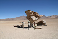
It is blinding and immense, not soft like the snow it appears to be, and etched into an eccentric patchwork quilt by the ridges left behind by water that rises to the surface. It doesn’t crumble easily; there are no footprints. The salt burns my chin where I’ve been resting my head on the ground to take perspective pictures of us popping out of wine bottles and hugging giant iPods. The trip ends in the train graveyard, an unlikely (read: only in Bolivia) tourist attraction of silent giants, after 3 days of car games and an unhealthy number of lollipops.

FUN FACT / QUOTE OF THE DAY: "Is there a Ritz in Bolivia?" “Ahahaha!…black people.” “Ok, but God made Israel for me.” “Hostile colon!” “Your Mom´s from Chile.”

Saturday, March 15, 2008

Back Post

It was not a good week, so instead I will back post something happy. This is a trip I took in the Cordillera Real last October, the Andean range northeast of Lake Titicaca in La Paz:

We leave from the town of Sorata, a few hours from La Paz and lush at barely 2700m. It is a well-established base camp for mountain expeditions, developed and traveler-friendly. We have a topo and Chris can navigate but the trails out of town cross and fade, so we hire a local guide to take us as far as a mountain pass before our first night’s campsite.
This is our guide, Don Octavio, and his burro Chato who Chris and I rename Bill-the-pony.
The first day is a brutal 5600-foot climb to where we plan to camp for the night, the abandoned mines at Titisani, 4400m. It takes less than two hours of ascent for me to pledge my lifelong love for the burro, who is carrying our packs.
The hiking group looks something like this: Don Octavio, of Andean superior lungpower, and Chris, whose leg:vertical being ratio is abnormally high and hikes like he is racing……here’s the burro………………………………here’s me.
Not visual enough? Ok, here’s me with the group at 9000ft:


Here’s me “with the group” at 11000ft:


Humbled, I concentrate on how amazing it is to be here; the spring of moist pasture under my boots, tiny Sorata in the valley below, the welcome bite of primitive wind across my flushed face and the thud of my heartbeat in my ears as we gain altitude and lose air. It is barely noon when the fog moves in, ghostly beautiful over ponds lying like mirrors in grass and crumbled shale, but I have to strain to keep sight of Chris and Don Octavio.


At 5.5 hrs, we have reached 14300 ft at a corte, a pass in the mountain that descends steeply to the mines. We are in the center of a drizzling cloud as we bid adieu to Don Octavio and Chato and shoulder our packs. The rain becomes definitive as we scramble/slide down the black, flaky scree on the other side of the pass. It is steep and past where we stand the bottom disappears promptly from view, covered by fog, but I don’t need a visual to cling to the mountain side. If the fog were sulphuric steam, this would be Mordor.


The mines would probably make a good camp if it weren’t suddenly a hundred simultaneous mountain streams. This was the chance we took coming so late in the season. Every flat spot that is not a little pond is piled with cow paddies. We find a tiny niche in the rocks just big enough for my Northface Tadpole. I devour an entire bag of M&Ms before we even start cooking dinner. I love backpacking. In the morning, it is still and the light illuminating the rain fly is inconclusive, bright but not sunny. We pile out of the tent; sun!!
Well, brief sun, a glimpse of the amazing view below that should be haunting each step of this trip, then the fog moves back in.
Up, up, up. Step, breathe, step, breeeathe. Last 2000 ft of climb but in the fog and water running all down the mountain we lose the trail to the Laguna Glacier. A myriad of rock cairns lead us up over a moraine. We reach the top – GLACIER! But not the right one. It’s unidentified on the map so Chris names it Tortila and I name it Baby Llama and we call it a day.
We’re at 5000m, no altitude sickness but I can’t sleep. It’s snowing, which caps the tent like saran wrap and the condensation drips on my face all night while the thunderous sound of glacial ice calving sounds a lot spookier and closer now that I’m trapped in a tent.


The morning is brilliant in blue and white. Breakfast, the worst muesli in the world, freezes to my hand. I settle for my mountain mocha (Nescafe+Swiss Miss) and my glacier view. We spend the morning hiking over the next moraine but still no Laguna Glacier. The unwelcome fog drifts back in and we enjoy our last view of Lake Titicaca from 16000 ft.


The descent is interchanging vistas and fog. We pound down 1000m over boulder fields until we reach Laguna Chillata, where the fog lifts for a final view of the cordilleras.
The Cordillera Real is 100 miles, from Illimani overlooking La Paz in the southern end at 21125ft to the northern view before me, in the shadow of Illampu (20892ft) and Ancohuma (21086ft).
Back down to sub-9000ft. Fin!